
Still We Rise Again
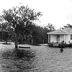
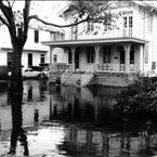
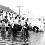
Images taken by the U.S. Corps of Engineers following Hurricane Betsy 1964
Aged and weathered cities all have their darkest hours, but somehow the ruins get better. Rome is still beautiful and has lived to tell the tale of its sackings by the Gauls, the Goths, the Vandals, the Ostrogoths, the Normans, and even a Renaissance Spanish army. The late Leonard Huber tells us that on the lower Mississippi river, thirty-eight floods occurred between 1735 and 1871 and nine of these inundated New Orleans. A levee break or crevasse in Kenner, he tells us, “brought water as far as Chartres St.” in 1816. The Sauve crevasse in 1849 “flooded 220 squares and drove 12,000 people from their homes.” The great crevasse at Bonnet Carre in 1871 propelled so much water from the river into Lake Pontchartrain that when a north wind blew the water toward the city, the Hagan Avenue levee broke and the city flooded. Still we rose again.
New Orleans has the distinction of flood threat from river, lake, and rainfall. The devastating hurricane of 1915 pounded the town with 120 mph winds, which segued in the next two weeks into 22 inches of downpour. The “Good Friday” rain of 1927 dumped 14 inches in one day while lightning disabled the power train to several pumping stations. The flood that year in the Mississippi Valley propelled the federal government to assume control of the river’s main line levees and install the Bonnet Carre Spillway to protect the city. Forty years later, four Times-Picayune reporters trumpeted in 1964 that New Orleans had not had a major (river) flood in a century, the year before Hurricane Betsy hurled 150 mph winds over the city, sinking ships in the river and topping the levees in the lower city and St. Bernard Parish. Although seven feet of lake water covered these areas, they still rebounded.
Disease, fire and mayhem?
If floods haven’t killed us, what about disease, fire, and mayhem? Again, Huber tells us that yellow fever struck twenty-three times before 1860, killing some 30,000 citizens. Asiatic cholera, especially in the 1830s, sent souls to their maker at a rate of nearly a thousand a month for a two-year period. People were buried in trenches, entire families taken, and carts for the dead piled high and in as short supply as housing in the flood zone. Four-fifths of the city–including the provision warehouses–burnt to the ground in 1788, leaving the citizens homeless and hungry. When the Irish merchant and American patriot Oliver Pollock delivered a shipload of flour and medicine to the city at regular prices, Governor Esteban Miro was so grateful he gave him a trading monopoly. Pollock later bought Elmwood Plantation with his business profits.
Those who count the Katrina aftermath as our darkest hour might consider 1794, when a hurricane struck on August 10, another brought rain and flood on the 21st, and the city (then just the French Quarter) burned a second time on December 8, followed by looting. Governor Carondelet faced the desolation without FEMA to blame or complain about and without America coming to the rescue with troops and billions of dollars. But the city rose again.
Our founders were not unaware of the “topographical challenges” to their early settlement. But at fourteen feet above sea level, with a ridge of land along Bayou Sauvage connecting it to the lake and thence to the Gulf of Mexico, the site of the Vieux Carre looked promising in 1718. All things being relative of course, it was promising in contrast with the cypress swamps that surrounded it, giving rise to 19th century street names like Marais (swamp, quagmire), the old name for the modern street alongside the Superdome. Need we say more about that? Accordingly, the first suburbs clung to the river, the Faubourgs St. Marie (1788) and Marigny (1806) being only seven to ten blocks deep as late as 1850. As the city grew upriver and the plantations one by one began to subdivide, they drew their rear lines at about Freret St.–the present uptown border of Katrina’s infamous crusty brown water line.
Technology, topography or human willfulness and spirit
Technological progress in the 20th century for the first time made all 200 square miles in the city limits “inhabitable,” including the Ninth Ward. The formidable A. Baldwin Wood pumping system went on line in 1908, after which the city’s growth was “freed” of its topographical limitations. Citizens now refer to “The Pumps” like benign relatives, like a set of uncles looking after us. It is well to note that it was not the pumps that failed us this time. The recent disaster still tested the assumptions of the 20th century, leaving those of earlier periods undamaged.
The issue now is whether the community should rely on engineering, topography, or the human ability to rise from the ashes whatever the catastrophe. If we follow the example of our forebears, the answer is obvious–build raised houses behind levees on higher ground and expect the next disaster. A favorite local icon is the sight of a ship riding in the river about twenty feet above the street leading to it. It reminds us that we live with danger. And we know we will rise again.
Sally Reeves is a noted writer and historian who co-authored the award winning series New Orleans Architecture. She also has written Jacques-Felix Lelièvre’s New Louisiana Gardener and Grand Isle of the Gulf – An Early History. She is currently working on a social and architectural history of New Orleans public markets and on a book on the contributions of free persons of color to vernacular architecture in antebellum New Orleans.